
Storm library

Browse live and recent hail maps.

Review storm footprints, hail swaths, reports, and replay access. Create a free account to save your setup and move into map access when a storm matters.

Search filters
Clear
Newest storms first by default.
Don't see your storm? Request a qualifying storm map and we'll email you when it is ready.
Showing 217-240 of 2367 storms · Page 10 of 99
‹ 1 9 10 11 99 ›
Request a storm map

Tell us about the storm and we'll build the map. Once it's published you'll get an email and can purchase it from the library — just like any other event.

Searcy, AR — August 22, 2026 — regional hail footprint preview
Storm footprint preview

Local hail summary for the Searcy area: 13.92 square miles of estimated ground-hail footprint; highest mapped band 1.5+ inches. 0 official hail report(s) within the summary area. Exposure estimates are not confirmed property damage. Open the map to explore the full coverage included in your access. Statistics cover the mapped hail footprint inside the Census boundary of Searcy, AR, not the entire region. The place had 22,937 residents in the 2020 Census. A boundary intersection does not mean the whole community was hit. Estimated housing exposure: 8,166 units in 1-inch-or-larger bands, including 1,578 in 1.5-inch-or-larger bands and 0 in 2-inch-or-larger bands.

Affected states: Searcy area, AR
1.5+ inRadar size estimate 20,565Population Affected 9,045Houses Affected HailHazards FreeAccount signup
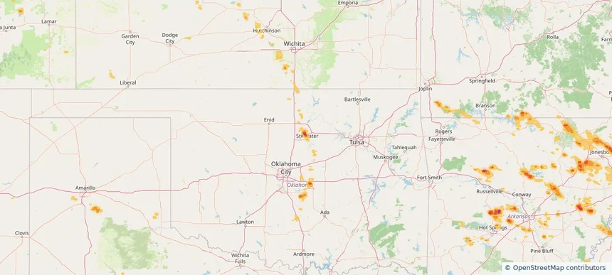
Stillwater, OK — August 22, 2026 — regional hail footprint preview
Storm footprint preview

Local hail summary for the Stillwater area: 2.72 square miles of estimated ground-hail footprint; highest mapped band 1.5+ inches. 0 official hail report(s) within the summary area. Exposure estimates are not confirmed property damage. Open the map to explore the full coverage included in your access. Statistics cover the mapped hail footprint inside the Census boundary of Stillwater, OK, not the entire region. The place had 48,394 residents in the 2020 Census. A boundary intersection does not mean the whole community was hit. Estimated housing exposure: 1,331 units in 1-inch-or-larger bands, including 69 in 1.5-inch-or-larger bands and 0 in 2-inch-or-larger bands.

Affected states: Stillwater area, OK
1.5+ inRadar size estimate 2,144Population Affected 1,331Houses Affected HailHazards FreeAccount signup
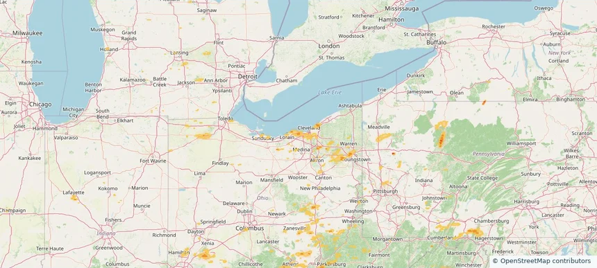
Westlake, OH — August 22, 2026 — regional hail footprint preview
Storm footprint preview

Local hail summary for the Westlake area: 11.38 square miles of estimated ground-hail footprint; highest mapped band 1+ inches. 0 official hail report(s) within the summary area. Exposure estimates are not confirmed property damage. Open the map to explore the full coverage included in your access. Statistics cover the mapped hail footprint inside the Census boundary of Westlake, OH, not the entire region. The place had 34,228 residents in the 2020 Census. A boundary intersection does not mean the whole community was hit. Estimated housing exposure: 2,069 units in 1-inch-or-larger bands, including 0 in 1.5-inch-or-larger bands and 0 in 2-inch-or-larger bands.

Affected states: Westlake area, OH
1+ inRadar size estimate 26,969Population Affected 12,025Houses Affected HailHazards FreeAccount signup
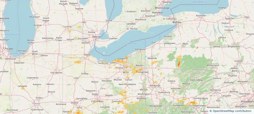
Wickliffe, OH — August 22, 2026 — regional hail footprint preview
Storm footprint preview

Local hail summary for the Wickliffe area: 3.42 square miles of estimated ground-hail footprint; highest mapped band 1+ inches. 0 official hail report(s) within the summary area. Exposure estimates are not confirmed property damage. Open the map to explore the full coverage included in your access. Statistics cover the mapped hail footprint inside the Census boundary of Wickliffe, OH, not the entire region. The place had 12,652 residents in the 2020 Census. A boundary intersection does not mean the whole community was hit. Estimated housing exposure: 1,012 units in 1-inch-or-larger bands, including 0 in 1.5-inch-or-larger bands and 0 in 2-inch-or-larger bands.

Affected states: Wickliffe area, OH
1+ inRadar size estimate 9,038Population Affected 4,192Houses Affected HailHazards FreeAccount signup
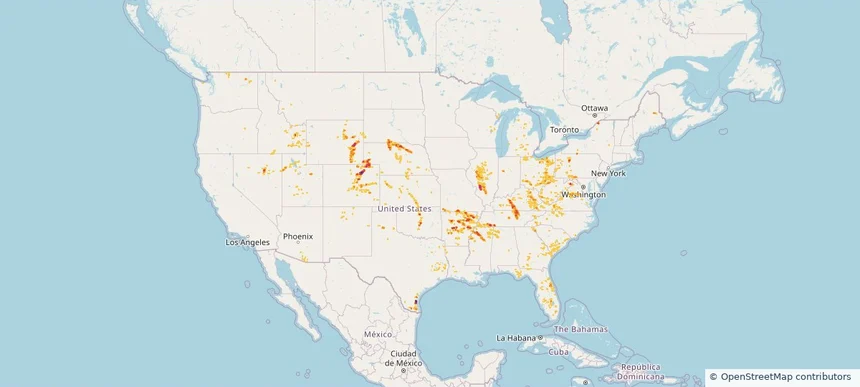
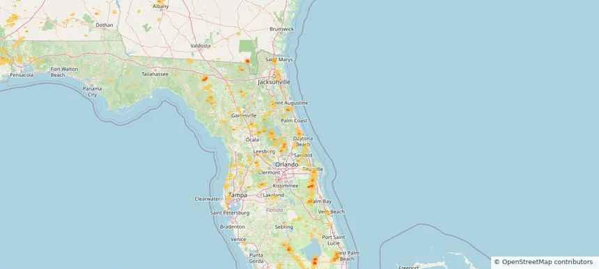
Nationwide Daily Hail, Wind & Tornado Map - August 22, 2026 — regional hail footprint preview
Storm footprint preview
Aug 21, 2026 10:00 PM to Aug 23, 2026 1:45 AM CST

Nationwide Daily Hail, Wind & Tornado Map - August 22, 2026

Hail as large as 2.50 inches was reported near Highland, IL. Wind up to 94 mph was reported near 3 miles north-northwest of Taber, ID. 3 tornadoes were reported, including one near 3 miles northwest of Ramey, PA. The storm had 34 official hail reports.

Affected states: National, AL, AZ, AR, CO, FL, GA, ID, IL, IN, KS, KY, LA, MD, MI, MS, MO, MT, NE, NV, NM, NC, OH, OK, PA, SC, SD, TN, TX, UT, VA, WA, WV, WI, WY
3.0 inRadar size estimate 1,337,049Population Affected 603,295Houses Affected Hail · Wind · TornadoHazards FreeAccount signup
Charlotte, NC — August 21, 2026 — regional hail footprint preview
Storm footprint preview

Local hail summary for the Charlotte area: 6.04 square miles of estimated ground-hail footprint; highest mapped band 1+ inches. 1 official hail report(s) within the summary area. Exposure estimates are not confirmed property damage. Open the map to explore the full coverage included in your access. Statistics cover the mapped hail footprint inside the Census boundary of Charlotte, NC, not the entire region. The place had 874,579 residents in the 2020 Census. A boundary intersection does not mean the whole community was hit. Estimated housing exposure: 8,016 units in 1-inch-or-larger bands, including 0 in 1.5-inch-or-larger bands and 0 in 2-inch-or-larger bands.

Affected states: Charlotte area, NC
1+ inRadar size estimate 25,249Population Affected 10,848Houses Affected HailHazards FreeAccount signup
Cleveland, TN — August 21, 2026 — regional hail footprint preview
Storm footprint preview

Local hail summary for the Cleveland area: 3.95 square miles of estimated ground-hail footprint; highest mapped band 1+ inches. 0 official hail report(s) within the summary area. Exposure estimates are not confirmed property damage. Open the map to explore the full coverage included in your access. Statistics cover the mapped hail footprint inside the Census boundary of Cleveland, TN, not the entire region. The place had 47,356 residents in the 2020 Census. A boundary intersection does not mean the whole community was hit. Estimated housing exposure: 404 units in 1-inch-or-larger bands, including 0 in 1.5-inch-or-larger bands and 0 in 2-inch-or-larger bands.

Affected states: Cleveland area, TN
1+ inRadar size estimate 6,833Population Affected 3,045Houses Affected HailHazards FreeAccount signup
Clinton, IA — August 21, 2026 — regional hail footprint preview
Storm footprint preview

Local hail summary for the Clinton area: 8.13 square miles of estimated ground-hail footprint; highest mapped band 1+ inches. 0 official hail report(s) within the summary area. Exposure estimates are not confirmed property damage. Open the map to explore the full coverage included in your access. Statistics cover the mapped hail footprint inside the Census boundary of Clinton, IA, not the entire region. The place had 24,469 residents in the 2020 Census. A boundary intersection does not mean the whole community was hit. Estimated housing exposure: 2,265 units in 1-inch-or-larger bands, including 0 in 1.5-inch-or-larger bands and 0 in 2-inch-or-larger bands.

Affected states: Clinton area, IA
1+ inRadar size estimate 7,398Population Affected 3,455Houses Affected HailHazards FreeAccount signup
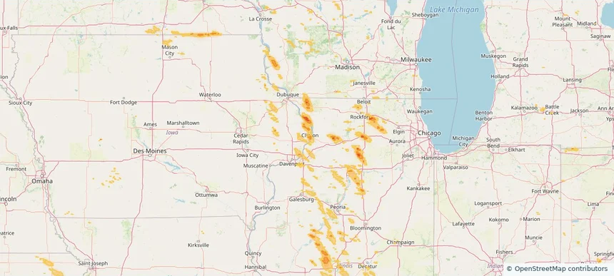
Dalton, GA — August 21, 2026 — regional hail footprint preview
Storm footprint preview

Local hail summary for the Dalton area: 1.40 square miles of estimated ground-hail footprint; highest mapped band 1.5+ inches. 0 official hail report(s) within the summary area. Exposure estimates are not confirmed property damage. Open the map to explore the full coverage included in your access. Statistics cover the mapped hail footprint inside the Census boundary of Dalton, GA, not the entire region. The place had 34,417 residents in the 2020 Census. A boundary intersection does not mean the whole community was hit. Estimated housing exposure: 853 units in 1-inch-or-larger bands, including 0 in 1.5-inch-or-larger bands and 0 in 2-inch-or-larger bands.

Affected states: Dalton area, GA
1.5+ inRadar size estimate 4,172Population Affected 1,707Houses Affected HailHazards FreeAccount signup
Decatur, AL — August 21, 2026 — regional hail footprint preview
Storm footprint preview

Local hail summary for the Decatur area: 10.30 square miles of estimated ground-hail footprint; highest mapped band 1.5+ inches. 0 official hail report(s) within the summary area. Exposure estimates are not confirmed property damage. Open the map to explore the full coverage included in your access. Statistics cover the mapped hail footprint inside the Census boundary of Decatur, AL, not the entire region. The place had 57,938 residents in the 2020 Census. A boundary intersection does not mean the whole community was hit. Estimated housing exposure: 1,138 units in 1-inch-or-larger bands, including 0 in 1.5-inch-or-larger bands and 0 in 2-inch-or-larger bands.

Affected states: Decatur area, AL
1.5+ inRadar size estimate 15,810Population Affected 6,804Houses Affected HailHazards FreeAccount signup
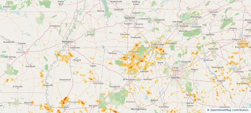
Eufaula, AL — August 21, 2026 — regional hail footprint preview
Storm footprint preview

Local hail summary for the Eufaula area: 3.86 square miles of estimated ground-hail footprint; highest mapped band 1+ inches. 0 official hail report(s) within the summary area. Exposure estimates are not confirmed property damage. Open the map to explore the full coverage included in your access. Statistics cover the mapped hail footprint inside the Census boundary of Eufaula, AL, not the entire region. The place had 12,882 residents in the 2020 Census. A boundary intersection does not mean the whole community was hit. Estimated housing exposure: 174 units in 1-inch-or-larger bands, including 0 in 1.5-inch-or-larger bands and 0 in 2-inch-or-larger bands.

Affected states: Eufaula area, AL
1+ inRadar size estimate 408Population Affected 174Houses Affected HailHazards FreeAccount signup
Florence, SC — August 21, 2026 — regional hail footprint preview
Storm footprint preview

Local hail summary for the Florence area: 2.09 square miles of estimated ground-hail footprint; highest mapped band 1.5+ inches. 0 official hail report(s) within the summary area. Exposure estimates are not confirmed property damage. Open the map to explore the full coverage included in your access. Statistics cover the mapped hail footprint inside the Census boundary of Florence, SC, not the entire region. The place had 39,899 residents in the 2020 Census. A boundary intersection does not mean the whole community was hit. Estimated housing exposure: 263 units in 1-inch-or-larger bands, including 0 in 1.5-inch-or-larger bands and 0 in 2-inch-or-larger bands.

Affected states: Florence area, SC
1.5+ inRadar size estimate 3,131Population Affected 1,324Houses Affected HailHazards FreeAccount signup
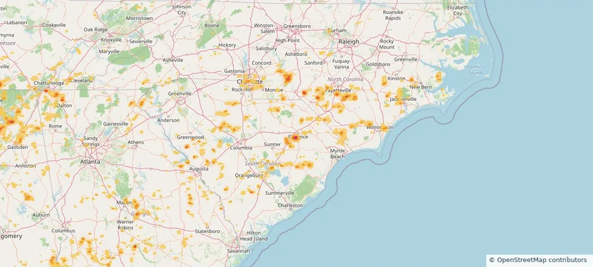
Fort Smith, AR — August 21, 2026 — regional hail footprint preview
Storm footprint preview

Local hail summary for the Fort Smith area: 3.09 square miles of estimated ground-hail footprint; highest mapped band 1.5+ inches. 0 official hail report(s) within the summary area. Exposure estimates are not confirmed property damage. Open the map to explore the full coverage included in your access. Statistics cover the mapped hail footprint inside the Census boundary of Fort Smith, AR, not the entire region. The place had 89,142 residents in the 2020 Census. A boundary intersection does not mean the whole community was hit. Estimated housing exposure: 3,140 units in 1-inch-or-larger bands, including 465 in 1.5-inch-or-larger bands and 0 in 2-inch-or-larger bands.

Affected states: Fort Smith area, AR
1.5+ inRadar size estimate 8,669Population Affected 3,807Houses Affected HailHazards FreeAccount signup
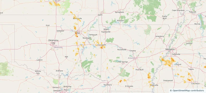
Huntsville, AL — August 21, 2026 — regional hail footprint preview
Storm footprint preview

Local hail summary for the Huntsville area: 26.70 square miles of estimated ground-hail footprint; highest mapped band 1.5+ inches. 0 official hail report(s) within the summary area. Exposure estimates are not confirmed property damage. Open the map to explore the full coverage included in your access. Statistics cover the mapped hail footprint inside the Census boundary of Huntsville, AL, not the entire region. The place had 215,006 residents in the 2020 Census. A boundary intersection does not mean the whole community was hit. Estimated housing exposure: 10,748 units in 1-inch-or-larger bands, including 1 in 1.5-inch-or-larger bands and 0 in 2-inch-or-larger bands.

Affected states: Huntsville area, AL
1.5+ inRadar size estimate 40,904Population Affected 18,635Houses Affected HailHazards FreeAccount signup
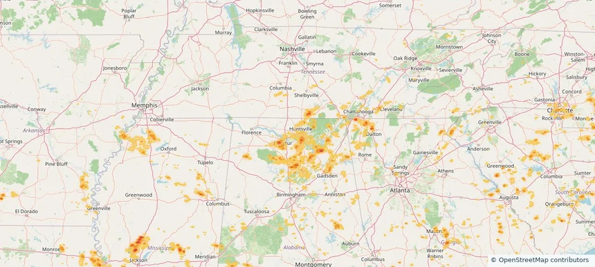
Monroe, NC — August 21, 2026 — regional hail footprint preview
Storm footprint preview

Local hail summary for the Monroe area: 1.95 square miles of estimated ground-hail footprint; highest mapped band 1+ inches. 0 official hail report(s) within the summary area. Exposure estimates are not confirmed property damage. Open the map to explore the full coverage included in your access. Statistics cover the mapped hail footprint inside the Census boundary of Monroe, NC, not the entire region. The place had 34,562 residents in the 2020 Census. A boundary intersection does not mean the whole community was hit. Estimated housing exposure: 521 units in 1-inch-or-larger bands, including 0 in 1.5-inch-or-larger bands and 0 in 2-inch-or-larger bands.

Affected states: Monroe area, NC
1+ inRadar size estimate 3,136Population Affected 1,151Houses Affected HailHazards FreeAccount signup
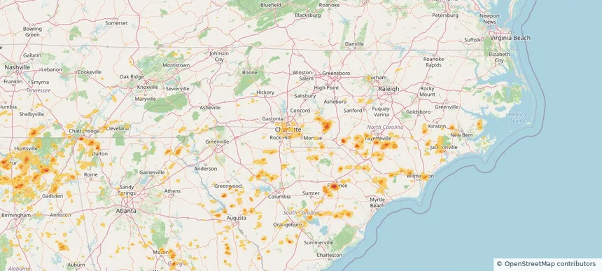
Murraysville, NC — August 21, 2026 — regional hail footprint preview
Storm footprint preview

Local hail summary for the Murraysville area: 5.67 square miles of estimated ground-hail footprint; highest mapped band 1+ inches. 0 official hail report(s) within the summary area. Exposure estimates are not confirmed property damage. Open the map to explore the full coverage included in your access. Statistics cover the mapped hail footprint inside the Census boundary of Murraysville, NC, not the entire region. The place had 16,582 residents in the 2020 Census. A boundary intersection does not mean the whole community was hit. Estimated housing exposure: 6,233 units in 1-inch-or-larger bands, including 0 in 1.5-inch-or-larger bands and 0 in 2-inch-or-larger bands.

Affected states: Murraysville area, NC
1+ inRadar size estimate 15,575Population Affected 6,810Houses Affected HailHazards FreeAccount signup
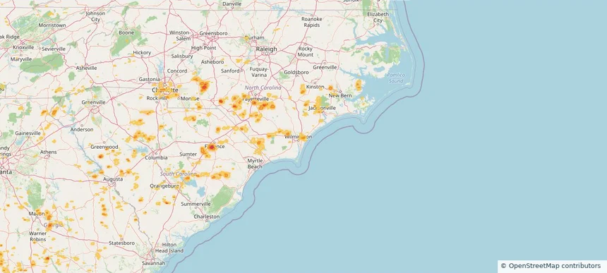
Overland Park, KS — August 21, 2026 — regional hail footprint preview
Storm footprint preview

Local hail summary for the Overland Park area: 11.23 square miles of estimated ground-hail footprint; highest mapped band 1+ inches. 0 official hail report(s) within the summary area. Exposure estimates are not confirmed property damage. Open the map to explore the full coverage included in your access. Statistics cover the mapped hail footprint inside the Census boundary of Overland Park, KS, not the entire region. The place had 197,238 residents in the 2020 Census. A boundary intersection does not mean the whole community was hit. Estimated housing exposure: 10,008 units in 1-inch-or-larger bands, including 0 in 1.5-inch-or-larger bands and 0 in 2-inch-or-larger bands.

Affected states: Overland Park area, KS
1+ inRadar size estimate 40,051Population Affected 15,815Houses Affected HailHazards FreeAccount signup
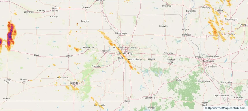
Sapulpa, OK — August 21, 2026 — regional hail footprint preview
Storm footprint preview

Local hail summary for the Sapulpa area: 1.73 square miles of estimated ground-hail footprint; highest mapped band 1.5+ inches. 0 official hail report(s) within the summary area. Exposure estimates are not confirmed property damage. Open the map to explore the full coverage included in your access. Statistics cover the mapped hail footprint inside the Census boundary of Sapulpa, OK, not the entire region. The place had 21,929 residents in the 2020 Census. A boundary intersection does not mean the whole community was hit. Estimated housing exposure: 396 units in 1-inch-or-larger bands, including 300 in 1.5-inch-or-larger bands and 0 in 2-inch-or-larger bands.

Affected states: Sapulpa area, OK
1.5+ inRadar size estimate 993Population Affected 399Houses Affected HailHazards FreeAccount signup
Nationwide Daily Hail, Wind & Tornado Map - August 21, 2026 — regional hail footprint preview
Storm footprint preview
Aug 20, 2026 10:00 PM to Aug 22, 2026 1:45 AM CST

Nationwide Daily Hail, Wind & Tornado Map - August 21, 2026

Hail as large as 3.00 inches was reported near 6 miles east-northeast of Oelrichs, SD. Wind up to 96 mph was reported near 2 miles east-southeast of Oakley, KS. 6 tornadoes were reported, including one near 4 miles southeast of Sublette, IL. The storm had 17 official hail reports.

Affected states: National, AL, AZ, AR, CO, FL, GA, ID, IL, IA, KS, LA, MI, MN, MS, MO, NE, NV, NM, NY, NC, OH, OK, SC, SD, TN, TX, UT, WI, WY
5.45 inRadar size estimate 1,806,710Population Affected 794,437Houses Affected Hail · Wind · TornadoHazards FreeAccount signup
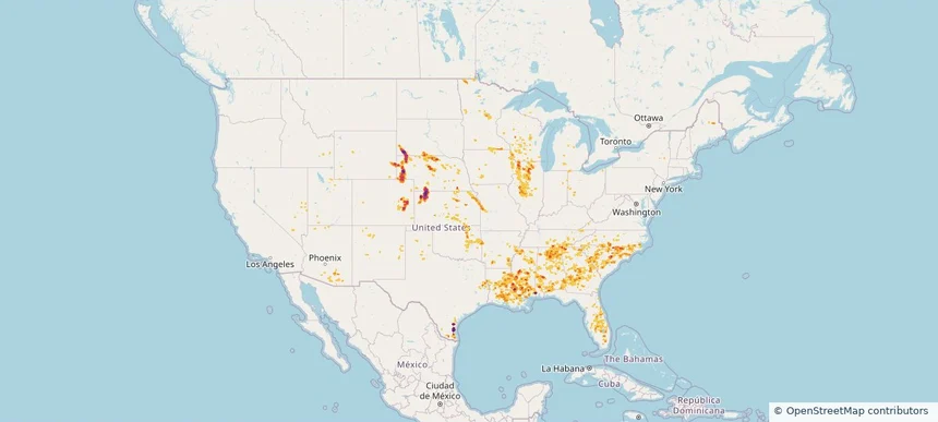
Brainerd, MN — August 20, 2026 — regional hail footprint preview
Storm footprint preview

Local hail summary for the Brainerd area: 10.01 square miles of estimated ground-hail footprint; highest mapped band 1+ inches. 0 official hail report(s) within the summary area. Exposure estimates are not confirmed property damage. Open the map to explore the full coverage included in your access. Statistics cover the mapped hail footprint inside the Census boundary of Brainerd, MN, not the entire region. The place had 14,395 residents in the 2020 Census. A boundary intersection does not mean the whole community was hit. Estimated housing exposure: 3,554 units in 1-inch-or-larger bands, including 0 in 1.5-inch-or-larger bands and 0 in 2-inch-or-larger bands.

Affected states: Brainerd area, MN
1+ inRadar size estimate 12,701Population Affected 5,723Houses Affected HailHazards FreeAccount signup
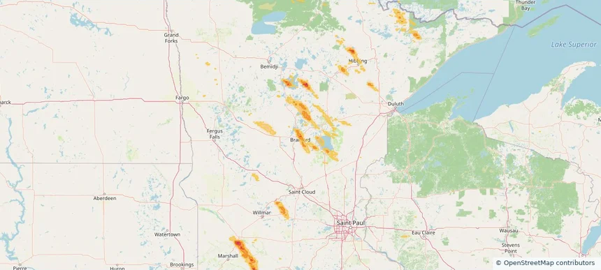
Cleveland, TN — August 20, 2026 — regional hail footprint preview
Storm footprint preview

Local hail summary for the Cleveland area: 3.95 square miles of estimated ground-hail footprint; highest mapped band 1+ inches. 0 official hail report(s) within the summary area. Exposure estimates are not confirmed property damage. Open the map to explore the full coverage included in your access. Statistics cover the mapped hail footprint inside the Census boundary of Cleveland, TN, not the entire region. The place had 47,356 residents in the 2020 Census. A boundary intersection does not mean the whole community was hit. Estimated housing exposure: 404 units in 1-inch-or-larger bands, including 0 in 1.5-inch-or-larger bands and 0 in 2-inch-or-larger bands.

Affected states: Cleveland area, TN
1+ inRadar size estimate 6,833Population Affected 3,045Houses Affected HailHazards FreeAccount signup
Colorado Springs, CO — August 20, 2026 — regional hail footprint preview
Storm footprint preview

Local hail summary for the Colorado Springs area: 26.22 square miles of estimated ground-hail footprint; highest mapped band 1.5+ inches. 3 official hail report(s) within the summary area. Exposure estimates are not confirmed property damage. Open the map to explore the full coverage included in your access. Statistics cover the mapped hail footprint inside the Census boundary of Colorado Springs, CO, not the entire region. The place had 478,961 residents in the 2020 Census. A boundary intersection does not mean the whole community was hit. Estimated housing exposure: 17,462 units in 1-inch-or-larger bands, including 666 in 1.5-inch-or-larger bands and 0 in 2-inch-or-larger bands.

Affected states: Colorado Springs area, CO
1.5+ inRadar size estimate 82,840Population Affected 40,169Houses Affected HailHazards FreeAccount signup
Dalton, GA — August 20, 2026 — regional hail footprint preview
Storm footprint preview

Local hail summary for the Dalton area: 1.40 square miles of estimated ground-hail footprint; highest mapped band 1.5+ inches. 0 official hail report(s) within the summary area. Exposure estimates are not confirmed property damage. Open the map to explore the full coverage included in your access. Statistics cover the mapped hail footprint inside the Census boundary of Dalton, GA, not the entire region. The place had 34,417 residents in the 2020 Census. A boundary intersection does not mean the whole community was hit. Estimated housing exposure: 853 units in 1-inch-or-larger bands, including 0 in 1.5-inch-or-larger bands and 0 in 2-inch-or-larger bands.

Affected states: Dalton area, GA
1.5+ inRadar size estimate 4,172Population Affected 1,707Houses Affected HailHazards FreeAccount signup
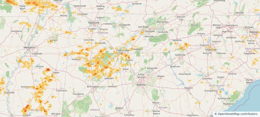
Daytona Beach, FL — August 20, 2026 — regional hail footprint preview
Storm footprint preview

Local hail summary for the Daytona Beach area: 7.59 square miles of estimated ground-hail footprint; highest mapped band 1+ inches. 0 official hail report(s) within the summary area. Exposure estimates are not confirmed property damage. Open the map to explore the full coverage included in your access. Statistics cover the mapped hail footprint inside the Census boundary of Daytona Beach, FL, not the entire region. The place had 72,647 residents in the 2020 Census. A boundary intersection does not mean the whole community was hit. Estimated housing exposure: 269 units in 1-inch-or-larger bands, including 0 in 1.5-inch-or-larger bands and 0 in 2-inch-or-larger bands.

Affected states: Daytona Beach area, FL
1+ inRadar size estimate 3,504Population Affected 2,114Houses Affected HailHazards FreeAccount signup
Page 10 of 99
‹ 1 9 10 11 99 ›

Frequently asked questions

Can I search hail maps by coverage area?

Yes. The storm library supports coverage-area filtering so you can find hail maps and hail swaths in a target service area.

What kinds of storms appear in the HailMapr library?

The library focuses on published hail events, including ready storm maps and live storms once hail has been detected and a public swath is available.

Are HailMapr storm pages useful for roofers and adjusters?

Yes. They are built to help roofers, adjusters, restoration teams, and property owners review storm footprints before purchase.